Sunday, 31 May 2015

Land Use and Agriculture in California


CalFire's 2010 Ownership of Forest and Rangelands in California
1) Agriculture is a major Californian industry. The amount of land devoted to farming and ranching in California remains at 25.4 million acres. (California Agriculture statistics, Crop year 2012) Approximately 33 million acres in California are forests. (Division of Agriculture and Natural Resources, University of California)  For urban land, 5.1% takes up of the state's land area. (Urban Forest Data)

2)
Polyculture farming: agricultural method of planting multiple crops in the same field

Polyculture pros:-faster sowing
-reduces pests and disease outbreaks
-better flavour and nutrition
-natural resources used more efficiently
-better polination
-improved yields
Polyculture cons:
-slower harvest
-difficult to calculate income and predict results
-seed loss/high up-front seed costs
-difficult to control
Monoculture farming: agricultural method involves planting one species of crop on the same piece of land repeatedly
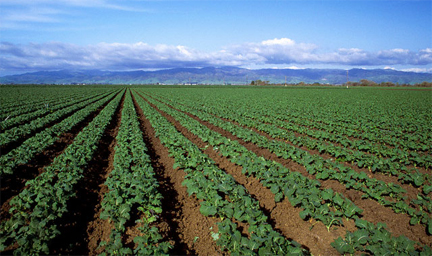
Monoculture pros:
-the field is in better position to provide maximum output for particular crop
-helps keep down farming costs
-knowledge of single species if sufficient for good crop
-is convenient
-easier
-less competition of sunlight, nutrients, and space from other species
Monoculture cons:
-does not support other flora and fauna
-disease can spread to whole crop *all plants
-limits chance of taking advantage of other nutrients in soil
-limited food options
-reduces nitrogen composition in soil
-soil fertility diminishes at a faster rate
-time consuming
Slash and burn: agriculture technique which involves cutting and burning forests or woodlands to create fields

Slash and burn pros:
-returns nutrients to soil
-controlled burn reduces fire risk of debris left on farm land
-cheaper to burn the debris on-site
-burns may be used to scare unwanted animals out
-may eliminate pests
Slash and burn cons:
-is a fire hazard
-site preparation may be longer
-may lead to erosion or leaching of nutrients
-releases greenhouse gases
-animals may be killed
-get out of control and cause damage; endanger lives

3)  Sustainable practices involve a variety of approaches. Strategies must take account topography, soil characteristics, climate, pests, local availability of inputs and individual grower's goals.  Diversified farms are usually more economically and ecologically resilient, which is why California is mostly pro polyculture. As previously mentioned agriculture is a main industry of California and is crucial to the economy. The risk of monoculture is that the loss of crop in any one year could put a farm out of business and/or seriously disrupt the stability of a community dependent in that crop.  By growing a variety of crops they are less susceptible to the radical price fluctuations associated with changes in supply and demand.
California grows over 400 different crops, some grown nowhere else in the nation. Crops include grapes, almonds, strawberries, oranges, and walnuts. The most important vegetable crops grown in the state are lettuce and tomatoes.  Half the nation's fruits, vegetables, and nuts come from California.
With the current California water crisis, the agriculture is in scrutiny right now. The current drought situation is jeopardizing all their advances. The governor is also demanding 25% reduction in water use.  Agriculture is under intense pressure to do more especially since the governor's mandatory cuts didn't include agriculture.

Tuesday, 26 May 2015

Water Dilemma: California

1) The idea of water conservation is an important issue and should be discussed more. In Canada, we possess only 7% of the world's renewable freshwater supply, so it is sad to see that we overuse and abuse this precious resource. In many underprivileged countries, they have to fight for clean drinking water.  I wasn't too shocked with the information that people didn't have access to clean water.  It is quite a general knowledge that is taught to students to show how fortunate we are and how we shouldn't take this resource for advantage.  Many people in different parts of the world don't have access to freshwater that they can consume and sometimes travel miles to attain water that's not even fresh.  I am very fortunate and grateful to live in a place where water is easily available and I'm sure many people that live here think so as well, but it doesn't mean that we have the right to abuse it just because it's accessible. What did shock me was that corporations were abusing water resources to make money and leaving villagers with nothing. It is horrible to think that companies like Coca Cola don't give villagers the right to access their own water.


2)  *I will be doing California as it is a part of West USA and is also a suggestion provided*

Currently in California they are experiencing their 3rd year of drought.  There are even headlines claiming that "Current California Drought is Driest in State's History; Scientists fear 'Megadroughts' On Their Way".

The water situation in California right now is so crucial that the state's ecisting water supply and storage facilities could not meet the state's needs. Aside from this, the state (and much of the West) relies heavily on relies heavily on snowpack each winter to resupply surface water streams and lakes. The lack of winter storms and record high-temperatures this past winter, snowpack in California is at an all time low.  The state's hydropower supply is also threatened when snowpack is scarce.  Exports in California are reliant on produce and most of the water in California is used for farming; the drought is causing farmers to suffer as there is the water use restriction up to 25% that was announced to help reduce demand.
"Once aquifers are depleted, the state will have no backup supplies to surface water. Desalination could make up some of the difference, but can be expensive and is energy-intensive."
Resource

Monday, 18 May 2015

Mass Wasting China-Case Study: The Oregonian


BREAKING NEWS - A massive landslide hits Zhouqu County, China

A quick introduction into the topography and of other relations to the landslide; China is extremely mountainous; weather has been experiencing torrential rains from the monsoon season. The region also experiences large and devastating earthquakes from time to time. Landslides occur because of the heavy rainfall and from the earthquakes occurring on steep slopes where the slipping soil causes landslides.  The anthropogenic causes of landslides are dams, clear cutting, undercutting, and so forth.

On August 7, a huge mudslide struck Zhouqu, in Gansu western China. More than 1200 people had been declared dead and 490 were still missing. This was the worst landslide in Zhouqu since records began; possibly the worst in China for 60 years.

Landslide in Zhouqu, China
A Xinhua news article published on Wednesday said the causes of the 
Zhouqu mudslide were the "mountainous terrain and loss of ground cover" 
and, according to the deputy director of the Department of Geological 
Environment at the Ministry of Land and Resources, "a lingering drought 
lasting almost 9 months in some local areas and the 2008 Sichuan 
earthquake that might have loosened the mountainside and caused some 
cracks are also reasons behind the devastating mudslide."


A 2006 report by Lanzhou University warned of the dangers presented by the destruction of the forests around Zhouqu for mining and agriculture, causing soil erosion and destabilizing hillsides.
"The hills have become highly unstable and easily subject to natural disaster of landslides and mudslides," the report said. "The situation is the result of deforestation, exploitative mining activities, construction of hydroelectric power plants and other development activities."
In more recent years, the construction of a highway and more than 40 hydroelectric power dams in the sharp-sided valleys has further destabilised the geology, according to Fan Xiao, a leading Chinese geologist based in Sichuan.
The area is extremely poor. Logging was banned there 12 years ago but people continued to cut down and sell trees on the mountainside to make a living.
A recent drought and the Sichuan earthquake two years ago may have weakened the rock face above the town, but our correspondent says protective measures and warning systems could have saved lives.
The government has promised to help people rebuild homes and buildings in the area but analysts are questioning if this is wise.
"The tragedy in Zhouqu is a reflection of the challenges and risks economic growth brings to poor regions," said Li Yan, climate change and energy campaigner for Greenpeace China.
The devastating landslide destroyed much of the infrastructure; villages; homes; killing and injuring a significant amount of people and animals. 
This landslide could've been prevented from stabilizing the ground and by building retaining walls that won't compromise the shear plane of the land.
Families should not return to homes because there could be a lot of destruction immediately after the landslide. Once everything has been recovered and repaired, that is when it is only safe to return. Prevention programs are created to prevent a future disaster. Many recovery efforts and assistance is available from other cities and service workers for the recovery of natural disasters such as this one in Zhouqu, China.   


Sunday, 3 May 2015

Northridge Earthquake

   The Northridge earthquake occurred at 4:30am on January 17, 1994.  Northridge is located approximately 30km northwest of Los Angeles.  This earthquake had a 6.9 moment magnitude with a duration of 10-20 seconds. The earthquake occurred along a "blind" thrust fault (it is buried), close to San Andreas fault. 
    The earthquake was caused mainly by a previously undiscovered strike-slip fault in Reseda.
   The number of fatalities in the Northridge earthquake was about 57. About 9000 people were injured. The fact that the earthquake occured at 4:30am lessened the death toll.
   The Northridge earthquake caused extensive damage to parking structures and freeway overpasses. A 2500 car parking garage at the California State University at Northridge collapsed. The earthquake caused and triggered landslides in the Santa Susana Mountains, Santa Monica Mountains, and wetsern San Gabriel Mountains. These landslides blocked roads and damaged water linesa as well as damaging homes. Because Northridge area has arid, dry soil thus having few liquefaction and ground failure effects. There were, although, damage due to fires. Estimates of total damage range between $13-40 billion. 
    The Universal Studios attraction had shut down during this time as well as Disneyland, Knott's Berry Farm, and Six Flags; all very popular attractions. 
   A respiratory disease called the Valley fever outbreak  occurred 8 weeks following the earthquake. It is believed that the spores were carried in large clouds of dust created by seismically triggered landslides. 
   The Northridge earthquake led to a number of legislative changes. Due to the large amount lost by insurance companies because of the earthquake, most insurance companies either stopped offering or severely restricted earthquake insurance in California. In response, the California Legislature created the California Earthquake Authority (CEA), which is a publicly managed but privately funded organization that offers minimal coverage. A substantial effort was also made to reinforce freeway bridges against seismic shaking, and a law requiring water heaters to be properly strapped was passed in 1995.

Monday, 27 April 2015

Plate Tectonics in West USA

Plates map of the world
                 

West USA is located in the North American Plate.


Western North America has two plate boundaries:
-San Andreas Fault; forming the most active part of the broad boundary zone between Pacific and North American plates
-Cascadia Subduction Zone: boundary along which the small Juan de Fuca plate subducts under the North American Plate

North American Plate:
The North American plate includes most of the North American continent, Greenland, and parts of Iceland and Siberia. Its motion can be measured on the order of a few centimeters per year. The edges of the North American plate show each of these three major plate boundary types: transform, convergent, and divergent. The movement of the hot mantle below the lithosphere drives the plate motion.
The North American plate collides and overrides the Pacific plate. It is moving to the west-southwest at about an inch per year away from the Mid-Atlantic Ridge.
The motion of the plate cannot be driven by subduction as no part of the North American Plate is being subducted.

The Juan de Fuca Plate is still actively subducting beneath N. America. Its motion is not smooth, but rather sticky; strain builds up until the fault breaks and a few meters of Juan De Fuca get slid under North America in a big earthquake. 
These plate motions are the primary source of strain in the lithosphere that lead to earthquakes in our region. In California, much of the strain generated by the grinding of the Pacific Plate against North America is taken up in earthquakes on the San Andres Fault and related structures but the shearing action dosn't end there.
California from one of Tanya Atwaters Plate Tectonics animations 
Volcanic arcs develop to the east of the North American subduction zone and created an ancient mountain range that preceded the modern Sierra Nevadas. Subduction stopped and the plate boundary off the coast of California was transformed from a trench into the modern San Andreas fault. 
The Appalachian Mountains, above in the U.S. state of West Virginia, are fold mountains. Fold mountains form over millions of years

PNW Vector Map
PNW Vector Map

            British Columbia however is part of rigid North America and moves with it. This results in the Puget Lowland being compressed and warped like an accordion with alternating uplifted and down warped terrain shortening the distance between Centralia, Washington, and the Canadia border. Dr. Ray Wells of the USGS developed a model to demonstrate this process and produced the cartoon animation located above the GPS Vector map. Source


Saturday, 11 April 2015

Mining

Part A

Shaft mining refers = the method of excavating a vertical/near-vertical tunnel from the top down, where there is initially no access to bottom.


Pro: • allows a mine operation to be 'hidden' having only head frames protrude above the surface, enabling land above zone of mining to be reclaimed for other uses after mining has ceased

       • can mine as deep as the development permits excavation to take place
       • it is not dependent on stripping ratios
       • does not affect physical environment as much
Cons: • safety issue is a big problem
          • underground mines produce significant amount of methane
          • expensive
          • collapses
          • flooding
          • mine explosions
          • miner can die due to lack of oxygen

Open pit mining =  is a surface mining technique of extracting rock or minerals from the earth by their removal from an open pit or borrow


Pro: • increase in efficiency over deep-shaft mining techniques

        • no space restrictions from narrow tunnels and shafts affect the rate at which ore can be extracted
        • sampling each level in an open pit before mining deeper allows surveyors to analyze potential yield and avoid safety hazards
        •  uses larger extraction vehicles, increasing amount of harvest per day
        •  reduced cost
        • safer than shaft mining
Cons: • loss of ecosystem
          • can take decades to recover
          • landslides and rockslides can occur without warning
          • acid mine drainage = serious environmental concern
          • release of dangerous metalloids in groundwater/local streams; polluted water can kill life along water source 


Part B

Spouse of a miner:
Of course I would want my spouse to work in an open pit. It's said to be much safer and at the end of the day that is what's important. I've heard that they end up acquiring more per day which would be beneficial to both the company and the employees, thus meaning it would be better for our family. It doesn't require ventilation and the worse that can happen is a landslide. I would rather have my spouse take those chances than a space collapsing in on itself. 

Owner of a mining company:
I would choose open pit mining. It's cheaper and more efficient. Using this method will sustain my company.  I would be able to harvest more ore or minerals or what have you. Shaft mining would sometimes require digging deeper to find what we're looking for.   Not only that, but it would be better for my employees as it would be safer as well. 

Environmentalist: 
Open pit mining has environmental hazards. Hardrock mining exposes rock that has lain unexposed for geological eras. When crushed, these rocks expose radioactive elements, asbestos-like minerals, and metallic dust. Aside from this contamination of surface and ground waters often generates problems with this method. 

Owner of a nearby ski resort:
I would think underground mining would be better as open pit mining has more leniency space wise. That would not be good for my business and it having a gigantic dug out hole near my ski resort can be an eyesore as well as dangerous to my guests. If any guests want to try skiing in this open pit as well especially if it became abandoned then we would be legally liable for any injuries or harm that may occur.  If it were abandoned then there would just be a gaping hole there.

Part C


Mining is prominent in the USA and has been active since colonial times.
Mining in Alaska has been predominantly for metals such as gold, silver, and zinc. Mined metal is a valuable export and source of cash income for workers, and mining jobs pay above the state average. Major mines are mostly owned by out-of-state corporations, leading most of their profits to be exported. Minerals are one of Alaska’s most important exports.  The total value of metal production and exploration in Alaska was just over $3.4 billion in 2012, representing around 7% of the gross state product, and producing several thousand jobs.  Mining pays a 2% state tax on its revenue.  
Prospectors are actively pursuing new mineral resources in Alaska.


Thursday, 9 April 2015

Waste Management - Alaska

Alaska disposes of their waste through: 
ARL = Anchorage (Alaska) Regional Landfill  
CTS = Central Transfer Station
They also have a Hazardous Materials Management


Solid waste disposal presents a challenge for Alaska. Alaska has a population of approximately 710,231 people. 72% of this population live in Anchorage, Juneau, or Fairbanks. The other 28% are scattered throughout the state in rural communities. Many of these communities are only accessible by boat or air travel which means that they have their own landfill since it would not be practical to ship their waste. They "accomadate to the multiple rural community landfills by designating a Class III landfill category. Class III landfills are not connected by road to a larger landfill or are more than 50 miles by road from a larger landfill and must serve fewer than 1500 people." 
Although this is the case, a 2008 article/journal brings attention that circumstances unique to Alaska create challenges for basic waste disposal and recycling that are not experienced in the lower 48 US states or in countries like Japan where space is limited. Programs available to separating recyclables from waste stream are often minimal and varying. 
Another problem that ensues are the Alaskan Native villages from rural areas that face illegal dumping issues. They struggle to find cost effective and safe alternative to open dumps.


To improve their waste management strategies, I believe they must have viable solid waste disposal options to ensure Alaskan tribe's and village's waste ends up in landfill or municipal solid waste incinerator and not an open dump.  This information and knowledge needs to also be promoted through community outreach to properly ensure that residents, villagers, and tribes are informed of the environmental issues they face by not properly disposing of waste. Problems of disposing food may cause wild animals to rummage through their waste.  Alaska tries to prevent this by encouraging to use and even create your own incinerator for your garbage that you can have in your backyard. I think this one is important as it will harm wildife less.