 |
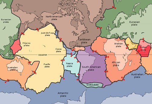
| Plates map of the world |

West USA is located in the North American Plate.
 |
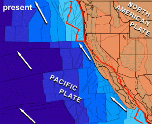
-San Andreas Fault; forming the most active part of the broad boundary zone between Pacific and North American plates
-Cascadia Subduction Zone: boundary along which the small Juan de Fuca plate subducts under the North American Plate
North American Plate:
The North American plate includes most of the North American continent, Greenland, and parts of Iceland and Siberia. Its motion can be measured on the order of a few centimeters per year. The edges of the North American plate show each of these three major plate boundary types: transform, convergent, and divergent. The movement of the hot mantle below the lithosphere drives the plate motion.
The North American plate collides and overrides the Pacific plate. It is moving to the west-southwest at about an inch per year away from the Mid-Atlantic Ridge.
The motion of the plate cannot be driven by subduction as no part of the North American Plate is being subducted.
The Juan de Fuca Plate is still actively subducting beneath N. America. Its motion is not smooth, but rather sticky; strain builds up until the fault breaks and a few meters of Juan De Fuca get slid under North America in a big earthquake.
These plate motions are the primary source of strain in the lithosphere that lead to earthquakes in our region. In California, much of the strain generated by the grinding of the Pacific Plate against North America is taken up in earthquakes on the San Andres Fault and related structures but the shearing action dosn't end there.
Volcanic arcs develop to the east of the North American subduction zone and created an ancient mountain range that preceded the modern Sierra Nevadas. Subduction stopped and the plate boundary off the coast of California was transformed from a trench into the modern San Andreas fault.
The North American plate collides and overrides the Pacific plate. It is moving to the west-southwest at about an inch per year away from the Mid-Atlantic Ridge.
The motion of the plate cannot be driven by subduction as no part of the North American Plate is being subducted.
The Juan de Fuca Plate is still actively subducting beneath N. America. Its motion is not smooth, but rather sticky; strain builds up until the fault breaks and a few meters of Juan De Fuca get slid under North America in a big earthquake.
These plate motions are the primary source of strain in the lithosphere that lead to earthquakes in our region. In California, much of the strain generated by the grinding of the Pacific Plate against North America is taken up in earthquakes on the San Andres Fault and related structures but the shearing action dosn't end there.
 |
| California from one of Tanya Atwaters Plate Tectonics animations |
 |
| The Appalachian Mountains, above in the U.S. state of West Virginia, are fold mountains. Fold mountains form over millions of years |
 |
|
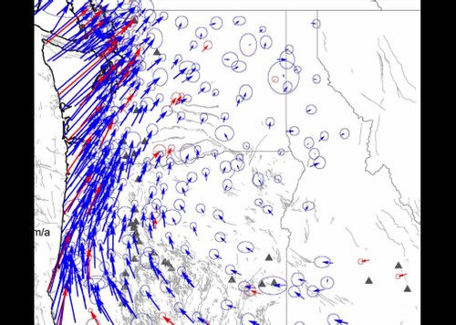
British Columbia however is part of rigid North America and moves with it. This results in the Puget Lowland being compressed and warped like an accordion with alternating uplifted and down warped terrain shortening the distance between Centralia, Washington, and the Canadia border. Dr. Ray Wells of the USGS developed a model to demonstrate this process and produced the cartoon animation located above the GPS Vector map. Source
|